The store will not work correctly in the case when cookies are disabled.
Your company account is blocked and you cannot place orders. If you have questions, please contact your company administrator.
We use cookies to make your experience better.To comply with the new e-Privacy directive, we need to ask for your consent to set the cookies.Learn more.
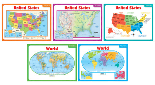
This versatile map set contains three United States maps, two world maps and an activity guide. Maps for the US are physical, political and color-coded regions. The world maps come with physical and political designations. Each glossy, brightly-colored map measures approx. 24" x 18". Perfect to hang on the school room or dining room wall or to lay flat on the desk top for game playing. ~Deanne
Publisher's Description of Teaching Maps (5-Map Set)
A wonderful resource for teaching social studies, geography, cultures, and more!Includes 5 pieces: United States political map United States physical map United States regions World political map World physical map
Have a question? Ask owners.Have a question about this? Ask people who own it.
Start typing and see existing answers.
Instant Answers
Start typing and we'll see if it was already asked and answered.
If there aren't already some matches, submit a new question.
You'll get fast answers from customers who really own the item(s) and from our product experts. (About half the time you'll get an answer in under 2 hours!)
Good Topics To Ask About
Which items will best meet your needs
What customers who own an item think of it
How to use, fix, or take care of an item
Product information
General advice related to the types of products we sell
Our store policies
Customer Support
For questions about an order you have placed, please contact customer support directly.
2 Questions
Why did you choose this?
Rainbow Resource CenterStore
Using for wall display.
Mary S
good learning tool
Camille D
need for geography class
Chazz M
I think the colors and print will really enhance my instruction. These maps are simple with not too much information on them to confuse young students.
Using for wall display.
good learning tool
need for geography class
I think the colors and print will really enhance my instruction. These maps are simple with not too much information on them to confuse young students.