We use cookies to make your experience better. To comply with the new e-Privacy directive, we need to ask for your consent to set the cookies. Learn more.
50 States Map - Large Foldable Blank (24" x 36")
SKU
019662
ISBN
9781893103962
Grade K-12
These icons are designed to help you quickly understand and learn important information about our products.
Teaching Method
Traditional
Teacher-centered curriculum commonly used in classrooms that may include a text, teacher manual, tests, etc.
Charlotte Mason
A methodology based on the work of a 19th century educator who maintained that children learn best from literature (Living Books), not textbooks.
Classical
A methodology based on the Latin Trivium (three stages of learning), including the grammar stage (memorization and facts), logic stage (critical thinking), and rhetoric stage (developing/defending ideas).
Unit Study
A thematic or topical approach centered around one topic that integrates multiple subject areas.
Montessori (Discovery)
A methodology based on the work of a 20th century educator that emphasizes student and sensory-driven discovery learning and real-life applications.
Other
Other methodologies
Religious Content
Secular
Contains content contrary to common Christian beliefs (i.e. evolution).
Neutral
Avoids religious or theoretical topics or presents multiple viewpoints without preference.
Christian/Religious
Faith-based or including instructional religious content.
Learning Modality
Auditory
Learns through listening, talking out loud or reading out loud.
Visual
Learns through seeing, prefers written instructions and visual materials.
Kinesthetic/Tactile (Hands-On)
Learns through moving, doing and touching.
Multi-Sensory
Curriculum that employ a variety of activities/components.
Presentation
Sequential
Curriculum progresses through well-defined learning objectives. Emphasizes mastery before moving to the next topic.
Spiral
Topics and concepts are repeated from level to level, adding more depth at each pass and connecting with review.
Conceptual/Topical
Focus is on the “why,” often with a unifying concept as well as specific skills; coverage may be broader.
Teacher Involvement
Low Teacher Involvement
Student-led materials; parent acts as a facilitator.
Medium Teacher Involvement
A mix of teacher-led time and independent student work.
High Teacher Involvement
Teacher-led lessons; may utilize discussions, hands-on activities and working together.
Additional Materials Required
No other materials needed
Everything you need is included.
Other Materials Required
There are additional required resources that are a separate purchase.
Other Materials Optional
There are additional resources mentioned or recommended but are not absolutely necessary.
Consumable
Consumable
Designed to be written in; not reusable.
Non-Consumable
Not designed to be written in; reusable.
Our Price
$16.95 $16.95 $12.95
Rainbow Savings: $4.00
Description
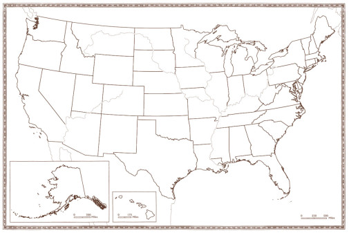
This large, heavy-duty map is flexible enough to be used in a variety of ways for learning! I love how user-friendly it is, folding to a small size quickly so it can be toted around or neatly stored away with books when not in use. Recommended for use with Beautiful Feet’s US Geography Through Literature curricula for both the Primary (K-3) and Intermediate (4-6th) grades. Made of consumable cardstock, it’s helpful for each student to have their own map for the year’s lessons, as they draw, color, and label all that they’re learning. ~Nancie
Publisher's Description of 50 States Map - Large Foldable Blank (24" x 36")
This is a beautiful map of the 50 states of the United States of America.
This large foldable map is designed for use with our Geography Through Literature Primary program. Chart the movements and events from this wide-ranging study with this accurate map printed on heavy-duty card stock.
Dimensions are 36" by 24", map folds down to 12" by 9" for easy storage. Students are encouraged to label cities, states, capitals, rivers, lakes, and national landmarks while coloring each state. At the end of the course this map will be a fun keepsake of all that was learned over the year.
We highly recommend that each student has their own map.
Category Description for Beautiful Feet Primary Curriculum (K-3)
Focusing on beautifully illustrated picture books, hands-on activities, and simple discussions, the focus is helping young children enjoy hearing quality literature and discussing it with others.
Details
| Product Format: | Other |
|---|---|
| Grades: | K-12 |
| Brand: | Beautiful Feet Books |
| ISBN: | 9781893103962 |
| Length in Inches: | 12 |
| Width in Inches: | 9 |
| Height in Inches: | 0.125 |
| Weight in Pounds: | 0.2 |
Videos
Reviews
No Ratings
Be the first to review this item
Have a question? Ask owners.
Start typing and see existing answers.
Why did you choose this?
Using with BFB Early American History Intermediate Level
We are going to study English through US geography. Students will create a map as we work through the country region by region. I like that this map is foldable to bring to class every week, but…
This is to go along with a CoOp geography class I am teaching....Road Trip USA
instructional level