The store will not work correctly in the case when cookies are disabled.
Your company account is blocked and you cannot place orders. If you have questions, please contact your company administrator.
We use cookies to make your experience better.To comply with the new e-Privacy directive, we need to ask for your consent to set the cookies.Learn more.
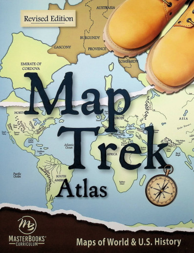
This full-colorhistorical atlas is amazing!You’ll
findchronological maps(beginning with the days of Noah) divided
into 4 time periods: Ancient, Medieval, New World, and Modern World. Over 200 high-resolutionmaps show the world during specific slices of time, allowing even children
to understand a huge amount of historical information in a compact way. This
book includes a complete set of all Map Trek colored maps with perforated
pages. The correlating Student
Outlines book includes all the same maps in a blank outline format so you
can label and draw with colored pencils, markers, and the like. Simple lesson
plans available online for FREE suggest activities for all ages and for
each map. Can be used flexibly alongside any history curriculum,
including the following Masterbooks History options:
Elementary:
Big Book of History
America’s Story 1-3
Jr. High and High School:
The World’s Story 1-3
American History
World History
Annals of the World
Reference Materials:
Adam’s Chart of History
Wonders of Old: A Blank Timeline
Book of World History
These are maps like no other, and you’ll want to reference
them time and time again throughout the years! This Atlas is also available in a SET with the Student
Outlines book.
Publisher's Description of Map Trek Atlas (Revised)
Time to take a trek through history!
Map Trek is an atlas that includes historical maps, allowing you to teach geography alongside history. This is a resource that any parent or teacher can use with brilliant success.
This highly useful map book for home educators was created for those who say they want...
Historical maps that navigate through history
Accurate maps that show the world THEN and NOW
Maps in high resolution.
Map Trek includes over 200 full-color maps, divided into four periods of time: Ancient World, Medieval World, New World, and Modern World. There is a comprehensive table of contents to help you find exactly what you need, and a detailed glossary of terms.
A perfect
supplement to any history or geography curriculum, Map Trek is a unique
atlas that includes historical maps that show the world from the days of Noah
through the Iraqi conflict in 2003. It also includes a map of the United States
as well as individual state maps. Two components are available: the Atlas and
the Outlines Book. These may be used together or independently to meet your
family’s needs. If you would like to use as a stand-alone resource, free Lesson
Plans are available on our website or from the publisher.
Great resource! Almost all of it 234 pages are maps! Old World, New World and America maps! No longer do you need to search the internet to find a particular map, its all here! This is perfect to pair with or add-on to any history course! Purchase it with the Map Trek Outlines and you have an entire geography course! Fantastic buy, that will serve you from elementary through high school and beyond! Also great for Bible study!
Shannon
Rated 5 out of 5
Sep 2, 2022
every home should have this atlas!
This atlas is a MUST have. I have kids in varying history and geography levels and this book is such a blessing! I have searched high and low for a really good atlas and have never been able to find one that could display all that this one can with so much historical content. You of course have your world and US maps but the modern world section is complete with maps of wars throughout history! THEN to make it even better there are maps from the very beginning of the ancient world, medieval world, new world, ending in the modern world.
This book is so perfect to pull out during a bible study to compare times and have a visual representation of what we are reading. We use it for my 3rd graders Americas Story lessons, my 7th graders Worlds Story lesson.. a child geography lessons the possibilities are literally endless!
Have a question? Ask owners.Have a question about this? Ask people who own it.
Start typing and see existing answers.
Instant Answers
Start typing and we'll see if it was already asked and answered.
If there aren't already some matches, submit a new question.
You'll get fast answers from customers who really own the item(s) and from our product experts. (About half the time you'll get an answer in under 2 hours!)
Good Topics To Ask About
Which items will best meet your needs
What customers who own an item think of it
How to use, fix, or take care of an item
Product information
General advice related to the types of products we sell
Our store policies
Customer Support
For questions about an order you have placed, please contact customer support directly.
1 Question
The first edition of MapTrek had instructions for three different levels of students. Does the revised edition still have different levels or any instructions? Or is just a book of maps?
The MT Atlas is just colored maps marked with country, regions, landmarks, bodies of water, travel routes, time period, etc. The MT Outlines are black and white outlines of a country/region and on certain maps travel routes and mountains. One page for each country/region. There are also pages with a grid for a student to draw a country/region by themselves. This is the book I see as being able to be adjusted to use at various levels, not the Atlas.