We use cookies to make your experience better. To comply with the new e-Privacy directive, we need to ask for your consent to set the cookies. Learn more.
Middle East Relief Map "Then and Now" Laminated (19.5" x 26")
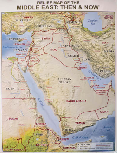
Easily see where Bible places are located today with its red "Then and Now" boundary linesand enjoy its stunning detailed relief of key mountains, valleys, rivers, and deserts within the Middle East. Perfect for Bible studies, Sunday school lessons, homeschool curriculum, and to display in your classroom, church hallway, or office.
See the boundaries of Israel, Egypt, Assyria and Babylonia during Bible times and how they compare to the modern-day location of Iran, Iraq, Egypt, Turkey, and Israel.
Usually the information included on this map is shown on two separate mapsbut for the first time ever Rose has combined this useful information onto one Bible wall map. Red print shows the major cities and boundaries of modern countries. Laminated for durability. Write on, wipe off with water soluble markers. Size: 19.5" x 26", heavy chart paper.
Rose Publishing has a reputation for producing quality Bible resources, like Then & Now Bible Maps. They have now published wall maps of the same great quality. The maps measure 19.5" x 26" and are laminated so you can write on/wipe off with water soluble markers. These are relief maps of the Middle East and the Holy Land, and the amazing details show mountains, mountain ranges, rivers, cities, towns, ancient ruins, and more. Modern locations are printed in red and ancient cities that are still in existence are underlined in red.
The back of each map has 4 reproducible worksheets related to the content of the map. The 7 1/2" x 10" worksheets on the reverse of the Holy Land map are black and white and include a present day (Now) map of the Holy Land, a map of what the Holy Land once looked like (Then), and two sheets that list Holy Land archeological sites. The Middle East map offers Then and Now black and white maps of the Middle East to reproduce along with two reference sheets for the Middle East and Scripture. These maps are beautiful and helpful when studying ancient history and/or the Bible. ~ Donna
Product Format: | Other |
---|---|
Brand: | Rose Publishing |
Grades: | 3-AD |
ISBN: | 9781628621600 |
Length in Inches: | 26 |
Width in Inches: | 19.375 |
Height in Inches: | 0.0625 |
Weight in Pounds: | 0.3 |
Rated 5 stars by 100% of reviewers
Rated 4 stars by 0% of reviewers
Rated 3 stars by 0% of reviewers
Rated 2 stars by 0% of reviewers
Rated 1 star by 0% of reviewers
- Start typing and we'll see if it was already asked and answered.
- If there aren't already some matches, submit a new question.
- You'll get fast answers from customers who really own the item(s) and from our product experts. (About half the time you'll get an answer in under 2 hours!)
- Which items will best meet your needs
- What customers who own an item think of it
- How to use, fix, or take care of an item
- Product information
- General advice related to the types of products we sell
- Our store policies
For questions about an order you have placed, please contact customer support directly.
Needed a simple map to show my pre-school & elementary-aged kids where the action takes place during our morning Bible time. Love that this has modern-day map overlay!
I purchased this map to go along with a course I am taking.
Good price