We use cookies to make your experience better. To comply with the new e-Privacy directive, we need to ask for your consent to set the cookies. Learn more.
United States Explorer Wall Map 32 x 20 - Laminated
SKU
047015
ISBN
9781597750097
Grade PK-AD
These icons are designed to help you quickly understand and learn important information about our products.
Teaching Method
Traditional
Teacher-centered curriculum commonly used in classrooms that may include a text, teacher manual, tests, etc.
Charlotte Mason
A methodology based on the work of a 19th century educator who maintained that children learn best from literature (Living Books), not textbooks.
Classical
A methodology based on the Latin Trivium (three stages of learning), including the grammar stage (memorization and facts), logic stage (critical thinking), and rhetoric stage (developing/defending ideas).
Unit Study
A thematic or topical approach centered around one topic that integrates multiple subject areas.
Montessori (Discovery)
A methodology based on the work of a 20th century educator that emphasizes student and sensory-driven discovery learning and real-life applications.
Other
Other methodologies
Religious Content
Secular
Contains content contrary to common Christian beliefs (i.e. evolution).
Neutral
Avoids religious or theoretical topics or presents multiple viewpoints without preference.
Christian/Religious
Faith-based or including instructional religious content.
Learning Modality
Auditory
Learns through listening, talking out loud or reading out loud.
Visual
Learns through seeing, prefers written instructions and visual materials.
Kinesthetic/Tactile (Hands-On)
Learns through moving, doing and touching.
Multi-Sensory
Curriculum that employ a variety of activities/components.
Presentation
Sequential
Curriculum progresses through well-defined learning objectives. Emphasizes mastery before moving to the next topic.
Spiral
Topics and concepts are repeated from level to level, adding more depth at each pass and connecting with review.
Conceptual/Topical
Focus is on the “why,” often with a unifying concept as well as specific skills; coverage may be broader.
Teacher Involvement
Low Teacher Involvement
Student-led materials; parent acts as a facilitator.
Medium Teacher Involvement
A mix of teacher-led time and independent student work.
High Teacher Involvement
Teacher-led lessons; may utilize discussions, hands-on activities and working together.
Additional Materials Required
No other materials needed
Everything you need is included.
Other Materials Required
There are additional required resources that are a separate purchase.
Other Materials Optional
There are additional resources mentioned or recommended but are not absolutely necessary.
Consumable
Consumable
Designed to be written in; not reusable.
Non-Consumable
Not designed to be written in; reusable.
Our Price
$14.99 $14.99 $12.50
Rainbow Savings: $2.49
Description
Category Description for Explorer Wall Maps
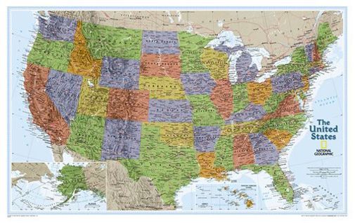
National Geographic is a trusted name for maps, and it is exciting for us to offer them in our catalog. The explorer series of wall maps are all the same size - 32" x 20" - but in different scales for the world (1:51,969,000) and the US (1:6,107,000). Easy to use and visually appealing, these make perfect additions to any classroom wall. The world map is done in a Winkel Tripel Projection with the Meridian of Greenwich at the center of the map. All lines of longitude show the differences in time zones. Inset charts on the world map list the world's largest countries by area and population, and the largest urban areas by population. The US map is done in an Albers Conic Equal-Area Projection and includes insets of Alaska and Hawaii at the bottom of the map as well as interstates and major highways. Countries and states on both maps are attractively shaded in hues of green, brown, and purple, and most major cities and airports, lakes, rivers, and mountains are detailed. Maps come in three formats: flat (which are rolled and secured with a rubber band), tubed (a paper map supplied in a plastic storage tube), and laminated. - Zach
Details
| Product Format: | Other |
|---|---|
| Brand: | National Geographic Maps |
| Grades: | PK-AD |
| ISBN: | 9781597750097 |
| EAN/UPC: | 749717203068 |
| Length in Inches: | 20 |
| Width in Inches: | 32 |
| Height in Inches: | 0.0625 |
| Weight in Pounds: | 0.15 |
Videos
Reviews
4 Ratings
4 Reviews
Rated 5 out of 5
May 26, 2020
Love
This is a large wall map. Extremely wonderful quality. Works great for (FIAR story discs)
Rated 5 out of 5
Sep 11, 2018
Perfect for Geography
This fits our need for a detailed map for our Geography curriculum.
Rated 5 out of 5
Aug 9, 2018
Quality Map
Good quality and great value!
Rated 5 out of 5
Feb 16, 2017
Laminated map of the US
Great quality map. I like that it is laminated. I can write on it with dry erase markers and erase with ease.
Have a question? Ask owners.
Start typing and see existing answers.
Why did you choose this?
I wanted something to hang in our classroom and put pins where we have been as a family.
accuracy of the map
I'm going to hang this in our hallway. I chose laminated so that we can also use dry erase markers on it.
Homeschool U.S. HIstory